Marion County remains under a tropical storm warning and flood watch
The county's shelters will open at noon and sandbag operations are still open.
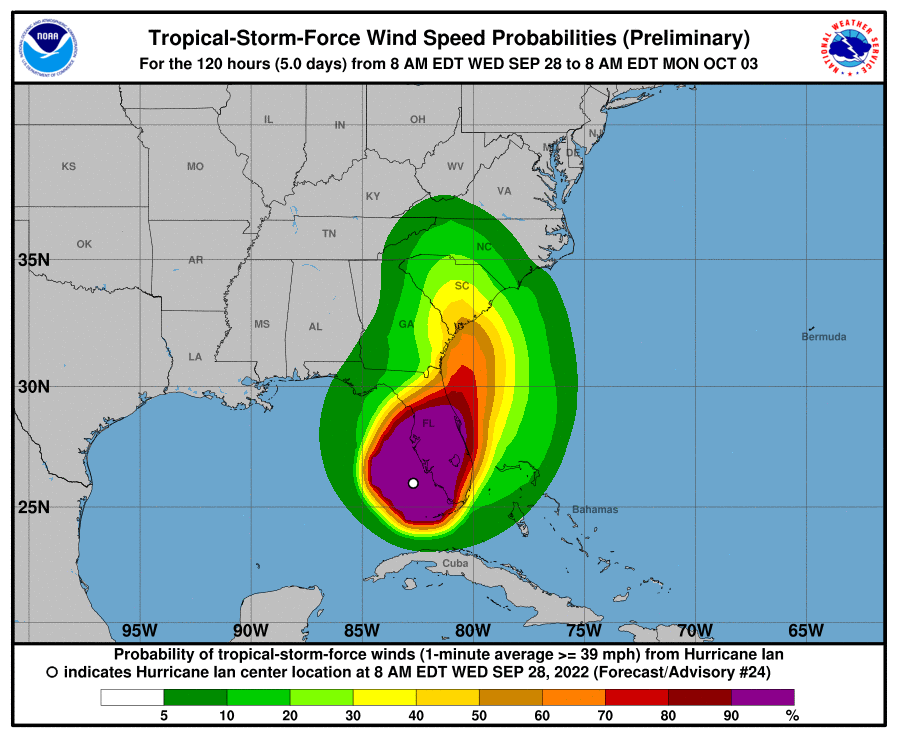
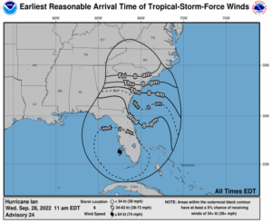
National Weather Service's 11 a.m. update for Marion County
------------------
Major Hurricane Ian, located near 25.6 north, 82.9 west at 5 AM EDT
Wednesday morning , is expected to move north northeast today while
decreasing in forward speed. A turn to the north is expected Thursday.
On this track, Ian is forecast to move toward southwest Florida and
make landfall on the southwest Florida coast this afternoon. Ian has
strengthened to a category 4 hurricane with maximum winds currently
near 140 mph with higher gusts.
A tropical storm warning and a storm surge warning remain in effect
for the entire northeast Florida coast and the entire St. Johns River
basin.
A tropical storm warning is in effect for Marion Counties.
The start of tropical storm winds likely are to begin tonight and
early Thursday morning across north central and northeast Florida, and
midday Thursday over parts of southeast Georgia.
Increasing rain chances are expected through the day from south to
north, with more rain and rain squalls and possibly embedded
thunderstorms occurring tonight through Friday. Heavy rainfall with
significant to extensive flash flooding is expected across parts of
northeast FL. A Flood Watch is in effect for for much of northeast
Florida and portions of southeast Georgia.
There is a concern for isolated tornadoes across parts of northeast
and north central Florida from this evening through at least Thursday
evening.

Marion County sandbag operations continue until 5 p.m. weather permitting.
Those locations are:
• Dunnellon City Complex, 11808 N Ohio St, Dunnellon, Florida 34431
• Wrigley Field, 405 County Rd East 316, Citra, FL
• East Marion Sports Complex, 14445 NE 14th Street Road, Silver Springs, FL
• Belleview Sports Complex, 6501 SE 107th St, Belleview FL
• Jervey Gantt Park, 2200 SE 36th Ave, Ocala, FL
• Tuscawilla Park (Reilly Arts Center), 800 NE Sanchez Ave, Ocala, FL
• Hampton Center, 1501 W Silver Springs Blvd., Ocala, FL
• Martel Recycling Center, 296 SW 67th Ave Rd, Ocala, FL
• Marion Oaks, 294 Marion Oaks Lane, Ocala, FL (Behind the Community Center)
West Port High, located at 3733 SW 80th Ave., opened yesterday as a hurricane shelter for those with special needs.
Today at noon, additional shelters will open:
Belleview Middle, located at 10500 SE 36th Ave. has capacity for 950.
Dunnellon High, 10055 SW 180th Ave. Road has capacity for 350.
Fort McCoy School, 16160 NE CR 315 has capacity for 300.
Hammett Bowen Jr. Elementary, 4397 SW 95th St. has capacity for 800.
North Marion Middle, 2085 W. County Road 329, has capacity for 300.
Vanguard High, the only pet friendly shelter located at 7 NW 28th St., has capacity for 2300
Support community journalism
The first goal of the Ocala Gazette is to deliver trustworthy local journalism so corruption, misinformation and abuse are not hidden from the public or unchallenged.