Storm Could Hit Florida as Hurricane
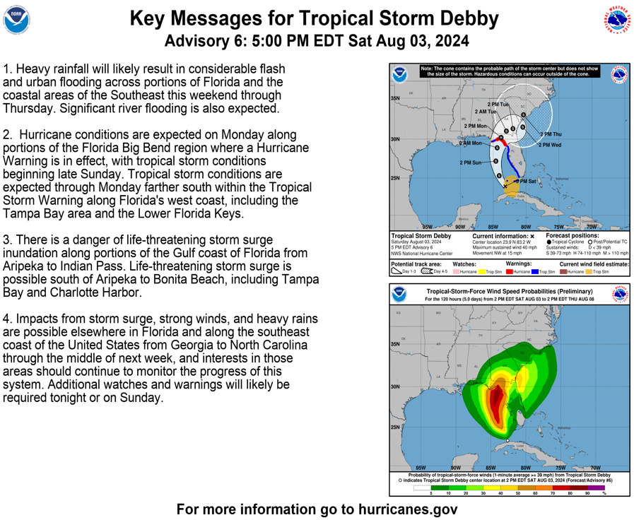
5:00 pm advisory Aug. 3, 2024 [Source: National Hurricane Center]
A Category 1 hurricane is forecast to make landfall Monday morning in North Florida’s Big Bend region, which the powerful Hurricane Idalia hammered nearly a year ago, according to the private meteorology company AccuWeather.
As the system, Tropical Depression Four, started to move into the southeastern Gulf of Mexico on Saturday afternoon, AccuWeather meteorologist Brandon Buckingham said conditions will lead to strengthening of the storm, which would be named Debby. Conditions include above-average water temperatures in the gulf.
“The combination of these factors opens up the possibility of rapid intensification between Saturday night and early Monday morning, including the final hours right up to the point of landfall,” Buckingham said in a statement.
As of Saturday afternoon, AccuWeather had the system making landfall with maximum sustained winds between 74 mph and 95 mph, a Category 1 hurricane on the Saffir-Simpson Hurricane Wind Scale. But Buckingham said the storm potentially could intensify to reach the Category 2 level before landfall.
Idalia grew briefly into a Category 4 storm before making landfall in Taylor County as a Category 3 hurricane on Aug. 30, 2023. The National Hurricane Center, in advisories on Saturday, also raised the prospect of a hurricane hitting Florida.
“After the system crosses Cuba and emerges over the eastern Gulf of Mexico, the environmental and oceanic conditions appear favorable for intensification,” the center said in an advisory. “Due to the lack of internal organization, the initial intensification is likely to be slow. However, a faster rate of development is likely once the system gets better organized, and the cyclone is likely to be near or at hurricane strength when it reaches the northern gulf coast.”
As of 2 p.m. Saturday, a hurricane watch had been issued from Indian Pass in Gulf County to Yankeetown in Levy County, according to the hurricane center A tropical storm warning had been issued from Yankeetown south to East Cape Sable in Monroe County and in the Florida Keys west of the Seven Mile Bridge.
Also, storm-surge watches and warnings had been issued for much of the state’s Gulf Coast.
“As you prepare your home remember that if you can pick it up, put it up!” the Florida Division of Emergency Management said in an online post. “Anything left outside could become dangerous projectiles in strong winds. Listen to all orders by local officials.”
The AccuWeather forecast included up to 8 inches of rain across the Florida peninsula and up to 12 inches in Northeast Florida. The hurricane center posted a potential “cone” showing the storm making landfall in the Big Bend and then moving east across North Florida and South Georgia.
AccuWeather also posted an advisory warning of tornadoes and waterspouts throughout the peninsula, rough surf and dangerous rip currents on both coasts, and rainfall totals of 12 inches to 18 inches in areas of the southeast U.S. over the next week.
Duke Energy Florida said Saturday it had mobilized more than 3,000 workers to respond to potential power outages. That includes crews from Duke Energy’s operations in Kentucky and Ohio.
____________________
As of 5:00 p.m.:
- Hurricane Watches have been issued for: Coastal Taylor, Coastal Dixie, Coastal Franklin, Coastal Wakulla, Coastal Jefferson and Levy counties.
- Tropical Storm Warnings have been issued for: Mainland Monroe, Coastal Collier, Coastal Lee, Coastal Charlotte, Sarasota, Manatee, Hillsborough, Pasco, Pinellas, Hernando, Citrus and Sumter counties.
- Tropical Storm Watches have been issued for: the Florida Keys including the Dry Tortugas (Coastal Monroe), Inland Lee, Inland Charlotte, DeSoto, Hardee, Polk, Lake, Inland Dixie, Inland Taylor, Inland Jefferson, Inland Wakulla, Inland Franklin, Liberty, Gadsden, Leon, Madison and Lafayette counties.
- Storm Surge Warnings are in effect for: Coastal Hernando, Citrus, Levy, Dixie and Taylor Counties.
- Storm Surge Watches are in effect for: Coastal Lee and Charlotte counties, including Charlotte Harbor, and Sarasota, Manatee, Hillsborough (including Tampa Bay), Pinellas and Pasco counties.
- A Coastal Flood Watch has been issued for the Florida Keys.
Support community journalism
The first goal of the Ocala Gazette is to deliver trustworthy local journalism so corruption, misinformation and abuse are not hidden from the public or unchallenged.