Development in pipeline off Maricamp Road, traffic issues a major concern
[Photograph courtesy of the City of Ocala]
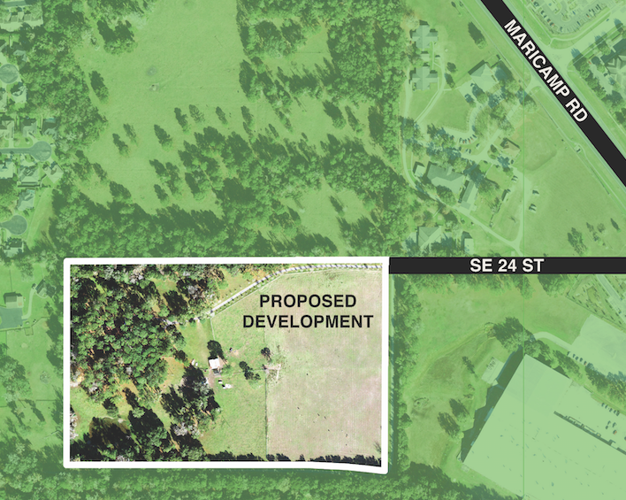
Owned by the Albright Family Trust, the property is accessed via an 8-foot-wide road that connects to the western end of Southeast 24th Street. The property was annexed into the city in 2006, but the zoning was never established.
Currently, one existing single-family residential home is located on the property.
“In September 2021, City Council approved a policy amendment for this property,” said Tye Chighizola, director of growth management for the city. “On Jan. 4, [the council] will consider the Concurrency Development Agreement and a rezoning to R-3.”
In anticipation of entering this agreement with the city, a traffic study was performed on Oct. 13 and projected that, based on the adopted level of service standards of the city and county, the intersection of SE Maricamp Road/SR 464 and Southeast 24th Street will have inadequate capacity at peak hour to accommodate projected new traffic generated by development of property.
The agreement stipulates that the density of the planned property shall not exceed a maximum of 180 single-family residential dwelling units or a maximum of 320 multi-family residential dwelling units—or any combination of residential types—so long as the traffic impact of whichever combination is chosen does not exceed the number of PM peak hour trips that would be generated by those assessed for 180 single-family units.
“PM peak hour trips” are the highest volume of traffic for a continuous hour between 4 p.m. and 6 p.m. during a typical weekday.
All other new developments impacting the same roadways, according to Chighizola, would be required to factor in the Albright trips as well.
“There are multiple projects within the vicinity but do not affect Southeast 24th Street directly,” said Aubrey Hale, a chief development official for the city.
However, Hale explained, the Maricamp Road project is located near a development of approximately 4.5 acres, consisting of five commercial lots. Other projects in the area include Maricamp Multi-Family and Maricamp & 25th Avenue subdivision. These projects are located north of the Albright parcel and adjacent to Maricamp Road and Southeast 25th Avenue. These projects are all still under review.
Under the development agreement, the city established a $37,500 payment from the developer for its proportionate share towards accommodations the city will have to make for increased traffic such as signal-timing adjustments that will allow for additional green lights to the eastbound, left-turn lane; an extension of the eastbound left-turning lane to allow for additional cars to queue; and installation of a “Right Turn on Red Must Yield to U-Turn” sign for the southbound right-turning lane from Southeast 24th Street to Maricamp.
Overall, city staff has recommended to the council that the Chapter 163 Concurrency Development Agreement addresses the concerns identified by the traffic study as well as provided additional requirements for buffers and architectural design while placing limitations on use, access, building height, lighting, and signage.
The city is not obligated to assume maintenance and control of the road that leads to the property from SE 24th Street until such time as the road is constructed to city standards.
Michael Lea expressed the concern for increased traffic on Maricamp Road that he and his neighbors in the adjacent development of Woodland Villages had during the Dec. 21 council meeting
“Traffic is a complete disaster at this time,” he said. “Solving this issue is going to be an extremely hard job. I’m not a traffic or civil engineer, but as my father once said, ‘Pants first. Then shoes.’ We need to get the traffic situation corrected before we start developing these parcels.”
“It’s a very challenging area,” agreed Councilman Jim Hilty. “And I think we need to make sure we visit that traffic pattern before we go forward.”
In addition to traffic, city staff, while approving of the project, identified that development of this property using either the current or proposed policy would likely contribute to localized overcrowding of nearby elementary and middle schools. Specifically, South Ocala Elementary, Osceola Middle, and Forest High could be directly affected.
At the time of the staff-drafted June 14 report for the Planning & Zoning Commission, South Ocala Elementary was at 99.3 percent capacity; Osceola Middle was at 111.8 percent; and Forest High was 89.9 percent.
That same staff report also mentioned that potable water service was available within a quarter of a mile from the development, while sanitary sewer service was available within 1/8 of a mile.
The second and final public hearing will be held at the council’s next scheduled meeting on January 4, 2022.
Support community journalism
The first goal of the Ocala Gazette is to deliver trustworthy local journalism so corruption, misinformation and abuse are not hidden from the public or unchallenged.