
Development Brief: 4805 SW 60th Avenue
Slated for Marion County BOCC Planning & Zoning meeting today at 1:30 pm.

[Image from Marion County]
Location: SW 60th Ave, south of SW 48th St, north of SW 52nd St, east of SW 60th Ave. Generally south/west of the Fore Ranch and Hunt Club neighborhoods, southeast of the post office and east of Peterson & Smith Equine Hospital.
Type of request: Initial rezoning. concept plan and PUD request
# of dwelling units on # of acres: 73 single-family detached dwellings units on 27.12 acres
# of commercial/retail space: None
UGB/FPA/POZ: Site is within the Urban Growth Boundary and in the Primary Springs Protection Overlay Zone
Links to staff report from agenda: https://marionfl.legistar.com/View.ashx?M=F&ID=13757052&GUID=F3501976-3AC2-4467-BA16-BD8AA0E01AC0
Commissioner/council district contact: District 5, Commissioner Michelle Stone [email protected]
Affected schools and current capacities per county staff report: “Saddlewood Elementary School (112.53% utilization), Liberty Middle School (92.63% utilization), and West Port High School (116.83% utilization).
While the local schools within the area are experiencing overcrowding, the school district as a whole has ample capacity for any new students generated by this development.”
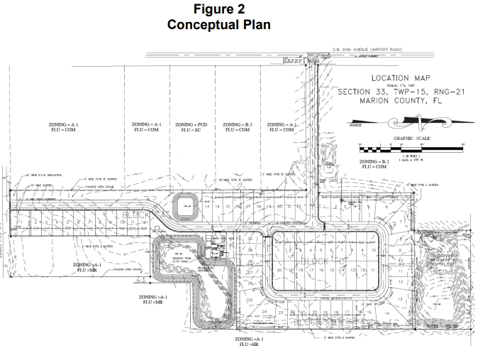
Notes of interest: From the staff report: “Staff recommends APPROVAL WITH CONDITIONS …shows proposed 73 single-family houses (one- or two-story). The overall p proposed density for the PUD is 2.69 dwelling units per acre. All residential houses will be no more than 35’ in height, and accessory structure’s maximum height will be 10’. The elevations of single-family houses can be found in Attachment A. The PUD proposes 6.68 acres of open space for the residential use including amenities such as dog park, play area, gazebo, and walk trail. ”
“Staff finds that the PUD proposes two access points for the PUD residential development. One through a driveway at SW 52nd St and the other through a driveway at SW 60th Ave.”
Other important notes from the staff analysis and report:
“The subject property previously operated as a Construction and Demolition (C&D) Landfill. Staff has been in contact with the Florida Department of Environmental Protection (Florida DEP) and has been informed that both the General Counsel and Central District cases related to this landfill have been closed, with no further monitoring currently required. However, any soil disturbance or redevelopment of the site will necessitate oversight by the Florida DEP. Specifically, the Florida DEP will be required to review and approve an Excavation and Disposal Plan, as well
as ensure compliance with all applicable regulations, before any development activities may commence. Also, a mining site is observed on a neighbor parcel. Applicant does not provide further information regarding the C&D landfill on the subject property and adjacent mining site.
On February 3rd 2025, applicant submitted a confirmation from FDEP that the site is cleared and no outstanding tasks at this moment.
Staff received a letter from Ocala International Airport and the City of Ocala expressing concerns about the subject property’s proximity—approximately 1.5 miles south of the airport. The letter states that residents will experience aircraft noise, dust, and fumes. To mitigate potential conflicts between aviation activity and residential development, the Ocala International Airport requests the inclusion of the following two conditions:
• An avigation easement shall be worked out to the satisfaction of Marion
County Office of County Engineering (OCE) and the Ocala International
Airport. A note shall be recorded on the final plat, acknowledging the
airport’s proximity and potential impacts from aircraft operations for the
property.
• The developer/HOA shall provide a residential disclosure statement to all
buyers, informing them of the airport’s presence, potential noise levels, and
other aviation-related impacts.
Conservation area on the north side of the property shall remain existing condition as a ‘no-touch’ buffer.
Part of the subject property is located in the flood zone. The PUD proposed two drainage retention areas to serve the site. During the Development Review phase, stormwater review will determine the size and depth of the retention area needed to serve the development.
Staff also noted the requirements for a full traffic study, hook-up to water/sewer systems and internal sidewalks.
Previous recommendations: The Development Review Committee and Planning & Zoning board recommended approval.
The item is slated for the Marion County BOCC Planning & Zoning meeting on February 17, 2025 at 1:30 pm.
[Image from Marion County]

Support community journalism
The first goal of the Ocala Gazette is to deliver trustworthy local journalism so corruption, misinformation and abuse are not hidden from the public or unchallenged.