
Helene an ‘Extremely Dangerous’ Category 4 Storm
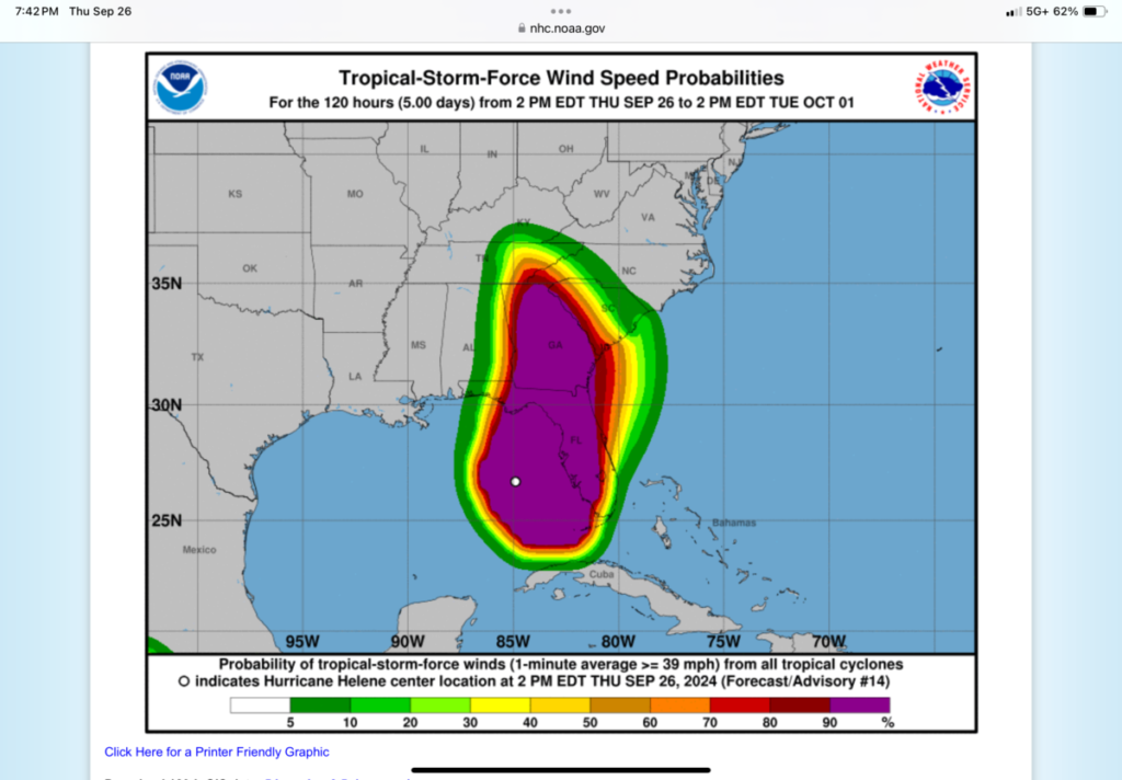
Note: The time of the tropical cyclone’s center location at the bottom of the graphic will be 3 hours earlier than the time of the current advisory. The forecast cycle for each advisory begins 3 hours prior to the issuance of the advisory products. These graphics show probabilities of sustained (1-minute average) surface wind speeds equal to or exceeding 34 kt (39 mph). These wind speed probability graphics are based on the official National Hurricane Center (NHC) track, intensity, and wind radii forecasts, and on NHC forecast error statistics for those forecast variables during recent years. Each graphic provides cumulative probabilities that wind speeds of at least 39 mph will occur during cumulative time periods at each specific point on the map. The cumulative periods begin at the start of the forecast period and extend through the entire 5-day forecast period at cumulative 12-hour intervals (i.e., 0-12 h, 0-24 h, 0-36 h, … , 0-120 h). An individual graphic is produced for each cumulative interval, and the capability to zoom and animate through the periods is provided. To assess the overall risk of experiencing winds of at least 39 mph at any location, the 120-h graphics are recommended. These probabilities will be updated by the NHC with each advisory package for all active tropical cyclones in the Atlantic and eastern North Pacific basins. While separate graphics are focused on each individual tropical cyclone, probabilities resulting from more than one active tropical cyclone may be seen on each graphic. It is important for users to realize that wind speed probabilities that might seem relatively small at their location might still be quite significant, since they indicate that there is a chance that a damaging or even extreme event could occur that warrants preparations to protect lives and property. [National Hurricane Center]
Gov. Ron DeSantis warned residents of the Big Bend region, including people in hard-hit Taylor County. to make final preparations for Hurricane Helene, which grew into a Category 4 storm forecast to make landfall late Thursday night.
“I think you’re looking at anywhere from that Jefferson County line over to Taylor County,” DeSantis said during an early evening news conference. “Most of the data we have does have a Taylor County landfall. But all those areas there, along the Big Bend coast, are areas that are low lying, that are susceptible to potentially major storm surge.”
While damage is expected to be widespread, DeSantis said the projected path had moved slightly east toward Taylor County, where Hurricane Debby made landfall last month and Hurricane Idalia hit in August 2023.
The National Hurricane Center said at 6:20 p.m. that maximum sustained winds had increased to 130 mph, making Helene an “extremely dangerous” Category 4 storm. Helene continued to grow as it moved north-northeast at 23 mph through the Gulf of Mexico. As of 7 p.m., the hurricane center said the storm was 110 miles west of Tampa and 145 miles south of Tallahassee.
Nearly 300,000 utility customers in the state did not have electricity Thursday afternoon, most in areas north and south of Tampa Bay. Large numbers of outages are expected after landfall.
“The storm is going to hit Florida’s Big Bend region sometime this evening, likely around 11 o’clock. It’s going to be dark,” DeSantis said during the news conference at the state Emergency Operations Center.
“Don’t go out as soon as that storm passes and it’s still dark and try to do work around your house or worry about things,” DeSantis said. “Let it get light. There’s going to be hazards there. It’s just not something you want to be navigating in the dark.”
Winds and storm surge had already forced closure of roads and bridges along the state’s West Coast, including the Howard Frankland and Sunshine Skyway bridges and Courtney Campbell Causeway in the Tampa Bay area.
“If you see water on top of the road or lapping over bridges, please do not drive over them, it’s going to be dangerous,” Florida Department of Transportation Secretary Jared Perdue said.
After landfall, storm-force winds are expected until nearly daybreak, Division of Emergency Management Director Kevin Guthrie said.

Support community journalism
The first goal of the Ocala Gazette is to deliver trustworthy local journalism so corruption, misinformation and abuse are not hidden from the public or unchallenged.